Key Well Level Information
Key Well State Well Numbers:
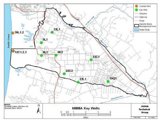
The Key Well State Well numbers can be found in the 2008 Nipomo Mesa Management Area Technical Group Annual Report Appendex B page 12:
Kev Wells State Well numbers:
11N/34W-19Q1
11N/35W-5L1
11N/35W-8L1
11N/35W-9K2
11N/35W-13C1
11N/35W-22C2
11N/35W-23L1
12N/35W-33L1
Key Well location Map from the NMMA TG:

The same wells are shown in the current report 2010 Nipomo Mesa Management Area Technical Group Annual Report Page 21 and in appendex B page 4 and 13, but the well numbers have been removed to attempt to hide the true identity and location of the wells:
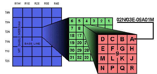
State Well Numbering System
The State Well Numbering system is based on the publicland grid, and includes the township, range, and section in which the well is located. Each section is further subdivided into sixteen 40-acre tracts, which are assigned a letter designation as shown in the figure below. Within each 40-acre tract, wells are numbered sequentially. The final letter of the State Well Number refers to the base line and meridian of the public land grid in which the well lies. "M" refers to the Mount Diablo base line and meridian; "S" refers to the San Bernardino base line and meridian. The San Bernardino base goes upto the northern tip of the Mesa and runs East to West along a line that goes along the road "Produce Place" in the Arroyo Grande Valley. In see DWR document for more detail.

For a copy most of the Nipomo area there is a county topo map that has been used to show the location of wells that are monitored. A copy can be found in the Public_Record_Requests at :
1995_0809_Request_for_SLO_Monitoring_Well_Levels_response.pdf________________3.7__mb
The area to the east is covered in the map from:
1996_0118_Request_for_SLO_Monitoring_Well_Levels_Map_11N35W_24G1_and_24D1_response.pdf_0.4__mb
Key Well latitude and longitude
Several data sources have the latitude and longitude associated with the well number. Most sources have latitude and longitude taken from topo maps when the well was drilled. There was a recent gps survey of wells done with the county around 2008. NCSD has released the newer gps latitude and longitude for most of the wells in it's work at: 2007 Spring Groundwater in storage REVISED for NCSD on page 4:
| State Well # | Owners Name - Street | latitude | longitude |
|---|---|---|---|
| 11N/34W-19Q1 | Benny - Division | 35.0138 | -120.4935 |
| 11N/35W-5L1 | Sackman - HWY#1 | 35.0615 | -120.5874 |
| 11N/35W-8L1 | Fire Station - HWY#1 | 35.0465 | -120.5878 |
| 11N/35W-9K2 | Schaefer - HWY#1/Willow | 35.0463 | -120.5671 |
| 11N/35W-13C1 | Arlt - Pomeroy | 35.0399 | -120.5169 |
| 11N/35W-22C2 | Woodlands, Flintcote well ? | 35.0234 | -120.5564 |
| 11N/35W-23L1 | 1743 Illinois Way ? | 35.0150 | -120.5354 |
| 12N/35W-33L1 | Johnson - Halcyon | 35.0732 | -120.5721 |
? were from the location listed in the 1995_0809_Request_for_SLO_Monitoring_Well_Levels and google maps gps numbers
Other sources have the older latitude and longitude numbers associated with the well number.
Key Wells on google maps and Bing maps
The latitude and longitude can be type in to Google maps, Google Earth or Bing maps to find the location and address:
| State Well # | Address | Google Maps | Bing Maps |
|---|---|---|---|
| 11N/34W-19Q1 | 1420 Division St. | Google Map | Bing Map |
| 11N/35W-5L1 | 2480 Tienda Pl. | Google Map | Bing Map |
| 11N/35W-8L1 | 2391 Willow Rd. | Google Map | Bing Map |
| 11N/35W-9K2 | 1983 Willow Rd. | Google Map | Bing Map |
| 11N/35W-13C1 | 804 Pomeroy Rd. | Google Map | Bing Map |
| 11N/35W-22C2 | Woodlands? | Google Map | Bing Map |
| 11N/35W-23L1 | 1743 Illinois Way ? | Google Map | Bing Map |
| 12N/35W-33L1 | 2047 S Halcyon Rd. | Google Map | Bing Map |
The address is from google maps.
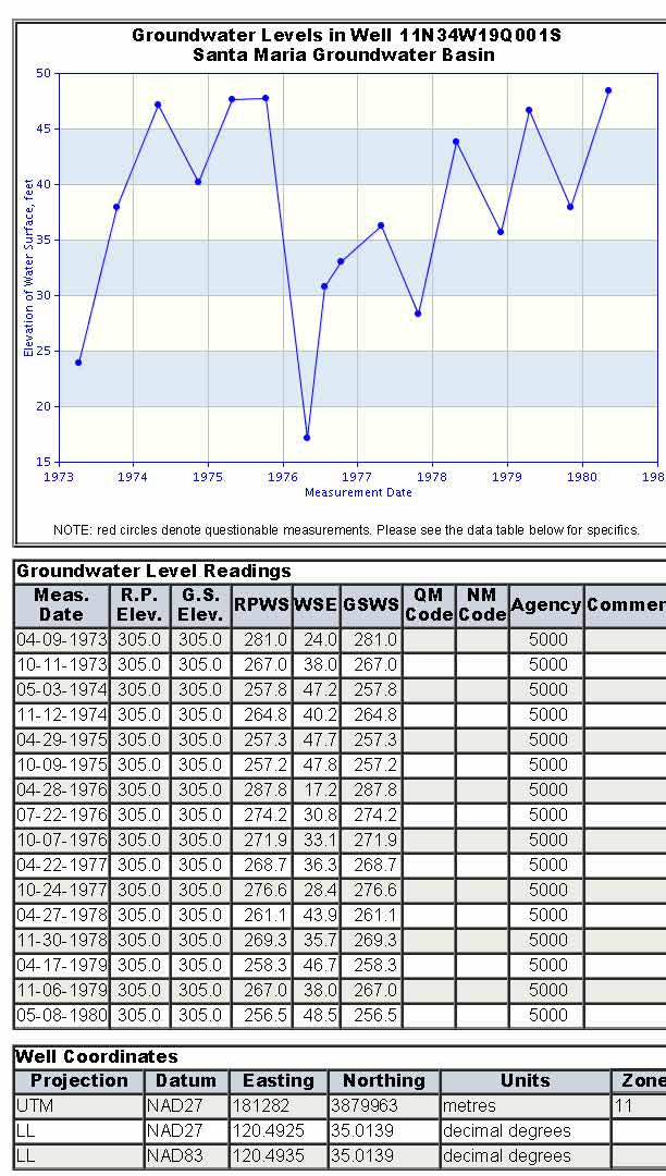
11N/34W-19Q1
1420 Division St.
DWR data on well http://www.water.ca.gov/waterdatalibrary/groundwater/hydrographs/report_html.cfm?wellNumber=11N34W19Q001S

11N/35W-5L1
11N/35W-8L1
11N/35W-9K2
11N/35W-13C1
11N/35W-22C2
11N/35W-23L1
12N/35W-33L1
1996 Water Resouce Mangement Study for the Woodland, USI, Cleath
1996 Water Resouce Mangement Study for the Woodland
1996 Water Resouce Mangement Study for the Woodland Data and Model
DWR data on wells can be found at:
http://www.water.ca.gov/waterdatalibrary/index.cfm
